Plug-In: Add Static Map 
Requires OmniFocus 4
DISCLAIMER: Mention of third-party websites and products is for informational purposes only and constitutes neither an endorsement nor a recommendation. OMNI-AUTOMATION.COM assumes no responsibility with regard to the selection, performance or use of information or products found at third-party websites. OMNI-AUTOMATION.COM provides this only as a convenience to our users. OMNI-AUTOMATION.COM has not tested the information found on these sites and makes no representations regarding its accuracy or reliability. There are risks inherent in the use of any information or products found on the Internet, and OMNI-AUTOMATION.COM assumes no responsibility in this regard. Please understand that a third-party site is independent from OMNI-AUTOMATION.COM and that OMNI-AUTOMATION.COM has no control over the content on that website. Please contact the vendor for additional information.
This plug-in uses the online Mapbox service to generate and add a static map image using the first map URL stored in the notes of the selected project or task.
When the plug-in is launched for the first time, you will be prompted to enter your Mapbox customer API key. This API key is securely stored in the system keychain, and will not be displayed during the execution of plug-in which uses HTTPS to encrypt the Mapbox URL during transmission.
To reset the stored API key, hold down the Control key when launching the plug-in.
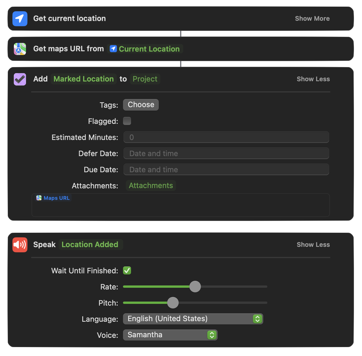
TIP: The Shortcut workflow shown in the following video run on an Watch, can be installed with this link.
(⬇ see below ) Shortcuts workflow for creating an OmniFocus task whose note contains a link to the current location.
| Video 1: Text Objects, Style Attributes, and Inline Attachments |
| Example: Adding static map to a note |
|
|
Return to: OmniFocus Plug-In Collection
Add Static Map for URL
/*{"type": "action","targets": ["omnifocus"],"author": "Otto Automator","identifier": "com.omni-automation.of.add-mapbox-image","version": "1.1","description": "This plug-in uses the online Mapbox service (www.mapbox.com) to generate and add a static map image using the first map URL stored in the notes of the selected project or task.","label": "Add Map from URL","shortLabel": "Add Map","paletteLabel": "Add Map","image": "mappin.and.ellipse"}*/(() => {var preferences = new Preferences()var credentials = new Credentials()var serviceTitle = "Mapbox"var shouldLog = falseconst requestCredentials = async () => {try {OSname = app.platformName// CREATE FORM FOR GATHERING ACCOUNT API KEYcredentialsForm = new Form()// CREATE TEXT FIELDkeyInputField = new Form.Field.String("APIKey",null,null)if(OSname !== "macOS"){keyInputField.autocapitalizationType = TextAutocapitalizationType.None}credentialsForm.addField(keyInputField)// VALIDATE THE USER INPUTcredentialsForm.validate = formObject => {APIKey = formObject.values["APIKey"]return (APIKey && APIKey.length > 0) ? true:false}// PRESENT THE FORM TO THE USERformPrompt = "Enter Mapbox API Key:"formObject = await credentialsForm.show(formPrompt, "Continue")// RETRIEVE FORM VALUESAPIKey = formObject.values["APIKey"]// STORE THE VALUEScredentials.write(serviceTitle, "Mapbox API Key", APIKey)// RETRIEVE CREDENTIALS OBJECTalertMsg = "The API key has been stored in the system keychain."alertTitle = "Confirmation"new Alert(alertTitle, alertMsg).show()}catch(err){if(!err.causedByUserCancelling){new Alert(err.name, err.message).show()}}}const fetchData = async mapboxURL => {try {if(shouldLog){console.log("FETCH", mapboxURL)}item = document.windows[0].selection.databaseObjects[0]noteObj = item.noteTextnStyle = noteObj.styletargetURLString = mapboxURLrequest = URL.FetchRequest.fromString(targetURLString)request.headers = {"Content-Type":"application/json"}request.method = 'GET'response = await request.fetch()responseCode = response.statusCodeif (responseCode >= 200 && responseCode < 300){wrapper = FileWrapper.withContents("static-map.png", response.bodyData)attachmentObj = Text.makeFileAttachment(wrapper, noteObj.style)if(noteObj.range.isEmpty){noteObj.insert(noteObj.start, attachmentObj)} else {newLineObj = new Text('\n', noteObj.style)noteObj.append(newLineObj, noteObj.style)noteObj.append(newLineObj, noteObj.style)noteObj.append(attachmentObj, noteObj.style)}node = document.windows[0].content.selectedNodes[0]node.expandNote(false)} else {throw {name: "Server Response Code",message: `The server responded with code: ${responseCode}`}}}catch(err){new Alert(err.name, err.message).show()}}const action = new PlugIn.Action(async function(selection, sender){try {// HOLD DOWN CONTROL KEY TO RESET VALUESif (app.controlKeyDown){credentialsObj = credentials.read(serviceTitle)if(!credentialsObj){throw {name: "Missing Credentials",message: "There is no stored Mapbox API key to remove."}} else {alertMessage = "Remove the stored Mapbox API key?"alert = new Alert("Confirmation Required", alertMessage)alert.addOption("Reset")alert.addOption("Cancel")alert.show(buttonIndex => {if (buttonIndex === 0){if(shouldLog){console.log(`Removing Service “${serviceTitle}”`)}credentials.remove(serviceTitle)if(shouldLog){console.log(`Service “${serviceTitle}” Removed`)}}})}} else {credentialsObj = credentials.read(serviceTitle)if(shouldLog){console.log("# CREDENTIALS READ")}if (credentialsObj){APIToken = credentialsObj["password"]// LOCATE FIRST MAP URL IN NOTEitem = selection.databaseObjects[0]noteObj = item.noteTextrunRanges = noteObj.ranges(TextComponent.AttributeRuns)mapLinkStr = nullfor (rangeIndx in runRanges){aRange = runRanges[rangeIndx]runStyle = noteObj.styleForRange(aRange)linkStr = runStyle.get(Style.Attribute.Link).stringif(linkStr.length > 0 && linkStr.includes("&ll=")){if(shouldLog){console.log("Map URL", linkStr)}mapLinkStr = linkStrbreak}}if(!mapLinkStr){throw {name: "Missing URL",message: "The note contains no map links."}}// ETRACT THE COORDS FROM THE MAP LINKurlComps = URL.Components.fromString(mapLinkStr)queryItems = urlComps.queryItemscoordsStr = nullfor (itemIndex in queryItems){queryItem = queryItems[itemIndex]if(queryItem.name === "ll"){coordsStr = queryItem.valueif(shouldLog){console.log("Latitude and Longitude", coordsStr)}break}}coords = coordsStr.split(",")aLatitude = coords[0]if(shouldLog){console.log("Latitude", aLatitude)}aLongitude = coords[1]if(shouldLog){console.log("Longitude", aLongitude)}// CONSTRUCT THE USER FORMmapStyleIndex = preferences.readNumber("mapStyleIndex")if(!mapStyleIndex){mapStyleIndex = 1}if(shouldLog){console.log("mapStyleIndex", mapStyleIndex)}mapStyles = ["Mapbox Light", "Mapbox Dark", "Mapbox Streets", "Mapbox Outdoors", "Mapbox Satellite", "Mapbox Satellite Streets"]mapURLStyleValues = ["light-v11", "dark-v11", "streets-v12", "outdoors-v12", "satellite-v9", "satellite-streets-v12"]mapStylesIndexes = [0,1,2,3,4,5]mapStyleMenu = new Form.Field.Option("mapStyleIndex","Style",mapStylesIndexes,mapStyles,mapStyleIndex)mapSizeIndex = preferences.readNumber("mapSizeIndex")if(!mapSizeIndex){mapSizeIndex = 0}if(shouldLog){console.log("mapSizeIndex", mapSizeIndex)}mapSizes = ["640x360", "360x640", "360x360", "480x480", "640x640"]mapDisplaySizes = ["640 x 360", "360 x 640", "360 x 360", "480 x 480", "640 x 640"]mapSizesIndexes = [0,1,2,3,4]mapSizeMenu = new Form.Field.Option("mapSizeIndex","Size",mapSizesIndexes,mapDisplaySizes,mapSizeIndex)mapZoomIndex = preferences.readNumber("mapZoomIndex")if(!mapZoomIndex){mapZoomIndex = 2}if(shouldLog){console.log("mapZoomIndex", mapZoomIndex)}mapZoomFactors = ["13", "14", "15", "16", "17"]mapZoomIndexes = [0,1,2,3,4]mapZoomMenu = new Form.Field.Option("mapZoomIndex","Zoom",mapZoomIndexes,mapZoomFactors,mapZoomIndex)shouldUseHighRes = preferences.readBoolean("shouldUseHighRes")if(!shouldUseHighRes){shouldUseHighRes = false}if(shouldLog){console.log("shouldUseHighRes", shouldUseHighRes)}highResCheckbox = new Form.Field.Checkbox("shouldUseHighRes","High-Resolution (@2x)",shouldUseHighRes)shouldUsePin = preferences.readBoolean("shouldUsePin")if(!shouldUsePin){shouldUsePin = true}if(shouldLog){console.log("shouldUsePin", shouldUsePin)}pinStatusCheckbox = new Form.Field.Checkbox("shouldUsePin","Include Location Pin",shouldUsePin)pinColorIndex = preferences.readNumber("pinColorIndex")if(!pinColorIndex){pinColorIndex = 0}if(shouldLog){console.log("mapZoomIndex", mapZoomIndex)}pinColorTitles = ["Red", "Green", "Blue", "Black", "White", "Gray", "Dark Gray", "Light Gray"]pinColorValues = ["f00", "0f0", "00f", "000", "fff", "808080", "a9a9a9", "d3d3d3"]pinColorIndexes = [0, 1, 2, 3, 4, 5, 6, 7]pinColorMenu = new Form.Field.Option("pinColorIndex","Pin Color",pinColorIndexes,pinColorTitles,pinColorIndex)inputForm = new Form()inputForm.addField(mapStyleMenu)inputForm.addField(mapSizeMenu)inputForm.addField(mapZoomMenu)inputForm.addField(pinStatusCheckbox)inputForm.addField(pinColorMenu)inputForm.addField(highResCheckbox)inputForm.validate = function(formObject){return true}formPrompt = "Select Mapbox map parameters:"buttonTitle = "Continue"// PRESENT FORM AND WAIT FOR RESULTSformObject = await inputForm.show(formPrompt, buttonTitle)mapStyleIndex = formObject.values['mapStyleIndex']if(shouldLog){console.log('mapStyleIndex', mapStyleIndex)}mapStyleValue = mapURLStyleValues[mapStyleIndex]if(shouldLog){console.log('mapStyleValue', mapStyleValue)}mapSizeIndex = formObject.values['mapSizeIndex']if(shouldLog){console.log('mapSizeIndex', mapSizeIndex)}mapSizeValue = mapSizes[mapSizeIndex]if(shouldLog){console.log('mapSizeValue', mapSizeValue)}mapZoomIndex = formObject.values['mapZoomIndex']if(shouldLog){console.log('mapZoomIndex', mapZoomIndex)}mapZoomValue = mapZoomFactors[mapZoomIndex]if(shouldLog){console.log('mapZoomValue', mapZoomValue)}shouldUsePin = formObject.values['shouldUsePin']if(shouldLog){console.log('shouldUsePin', shouldUsePin)}pinColorIndex = formObject.values['pinColorIndex']if(shouldLog){console.log('pinColorIndex', pinColorIndex)}pinColorValue = pinColorValues[pinColorIndex]if(shouldLog){console.log('pinColorValue', pinColorValue)}shouldUseHighRes = formObject.values['shouldUseHighRes']if(shouldLog){console.log('shouldUseHighRes', shouldUseHighRes)}resolutionValue = (shouldUseHighRes) ? "@2x":""// CONSTRUCT MAPBOX URLif(shouldUsePin){var urlStr = `https://api.mapbox.com/styles/v1/mapbox/${mapStyleValue}/ static/ pin-l+${pinColorValue}(${aLongitude},${aLatitude})/ ${aLongitude},${aLatitude},${mapZoomValue}/ ${mapSizeValue}${resolutionValue}?access_token=${APIToken}` } else {var urlStr = `https://api.mapbox.com/styles/v1/mapbox/${mapStyleValue}/ static/ ${aLongitude},${aLatitude},${mapZoomValue}/ ${mapSizeValue}${resolutionValue}?access_token=${APIToken}` }if(shouldLog){console.log("Mapbox URL", urlStr)}// STORE THE VALUESpreferences.write("mapStyleIndex", mapStyleIndex)preferences.write("mapSizeIndex", mapSizeIndex)preferences.write("mapZoomIndex", mapZoomIndex)preferences.write("pinColorIndex", pinColorIndex)preferences.write("shouldUsePin", shouldUsePin)preferences.write("shouldUseHighRes", shouldUseHighRes)if(shouldLog){console.log("# FETCHING DATA")}fetchData(urlStr)} else {if(shouldLog){console.log("# REQUESTING CREDENTIALS")}requestCredentials()}}}catch(err){if(!err.causedByUserCancelling){console.error(err.name, err.message)new Alert(err.name, err.message).show()}}});action.validate = function(selection, sender){singleItemIsSelected = (selection.databaseObjects.length === 1 &&selection.projects.length === 1 ||selection.tasks.length === 1)return singleItemIsSelected};return action;})();